Observing the ocean and atmosphere in the tropical Pacific is essential for local and global communities and their economies as it provides key insights into ocean, climate and weather variability and prediction, regionally and globally.
Improved ENSO Prediction
Better understanding of ENSO cycles allows for better predictions of extreme events that can have economic and human health impacts.

NASA’s Goddard Space Flight Center
The social and economic impact of the ability to predict El Niño and associated climate variations, and extreme events is well documented. These predictions have proven to be useful, but have not yet reached the level of skill and detail required to fully realize the potential benefits of sustained observation. Major advances will require enhanced collaboration, including shared planning and implementation, and targeted studies to address current gaps and systematic shortcoming in forecast systems.
Economy
Economic impacts of an ENSO vary greatly by country and sector, for example, while Australia, Chile, Indonesia, India, Japan, New Zealand, and South Africa economies are negatively impacted, the United States and Europe are positively impacted. As countries develop strategies for countering the effects of ENSO, improving ENSO prediction will help mitigate economic impacts through preparedness.
Human Health
Human health impacts can range from life-threatening, extreme events such as mudslides in Peru and fires in Australia to an increase in the spread of insect-borne illnesses, such as Malaria in East Africa.
Food Security
Changes in regional precipitation associated with ENSO can have large impacts on local agriculture and food security. ENSO has had measurable impacts on fisheries in almost every region of the Atlantic, Pacific, and Indian Oceans due to the changes in ocean habitats, e.g., the weakening or cessation of upwelling and coral bleaching. While globally the overall impact is weak, the impacts at local and regional levels can be severe.
El Nino Climate Impacts
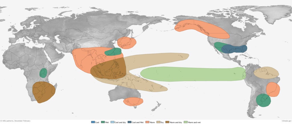
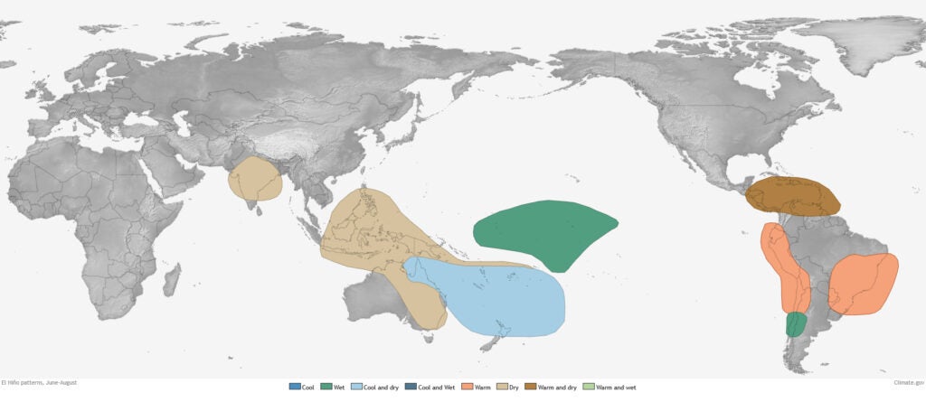
El Nino vs La Nina
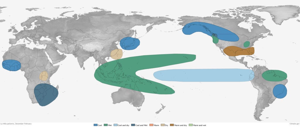
Maps from NOAA Climate.gov
Weather Prediction Service
Enhanced weather prediction benefits the safety and security of life and property during extreme events and the economy on seasonal and subseasonal levels.
TPOS allows us to gain a greater understanding of the tropical Pacific, better address the uncertainty of climate variability, and provide improved predictions and longer forecast lead times. The sea surface temperature and boundary layer condition observations from TPOS are critical elements of weather prediction. Better predictions of extreme climate episodes like floods and droughts could save billions of dollars in damage costs and help to improve community resilience globally. Improving our forecasting capabilities will profoundly impact agriculture, water management, marine ecosystems management, human health, and disaster preparedness.
Typhoons
Floods
Drought
Droughts can be devastating to many important agricultural regions as well as many small islands where rainfall provides their primary source of freshwater. In the U.S., drought events cost an average of 9.2 billion USD, in 28 events assessed since 1980. Drought events can also exacerbate wildfire disasters and lengthen wildfire seasons, as seen in 2020 in both Australia and the US. In these regions, drought is closely tied with El Nino cycles; better prediction of El Nino means countries can be better prepared when drought arrives.


Climate Change
High-quality physical and biogeochemical observations from the tropical Pacific Ocean will provide important input for detecting, understanding, attributing and projecting changes in the ocean and atmosphere, particularly on decadal and longer timescales.
Climate change will not only be damaging to ocean and terrestrial ecosystems, it poses severe threats to human health. The World Health Organization has estimated that between 2030-2050 climate change will cause 250.000 additional deaths from malnutrition, malaria, diarrhoea and heat stress, with the direct damage costs to health between USD 2-4 billion/year by 2030. The Intergovernmental Panel on Climate Change notes in its 5th Report that research, monitoring, and observations play a key role in our ability to adapt to the changing climate.
CO2 Flux
When averaged over the entire globe, the ocean absorbs carbon dioxide (CO2) from the atmosphere, but there are some regions where the ocean outgasses CO2 to the atmosphere. The Tropical Pacific is the largest of those regions, with annual CO2 outgassing as high as annual emissions from the entire European Union. As atmospheric CO2 increases and the ocean absorbs more of that CO2, elevating it’s own concentration, these areas of oceanic outgassing will become key to understanding the global status of this greenhouse gas.
Ocean Heat Content
Most of the heat (more than 90%) being added to the globe due to human-caused greenhouse gas warming is stored in the ocean. Because of this, it is critical to have high-quality, long-term records of sea surface temperature. In areas, like the eastern equatorial Pacific, however, the instrumental record is sparse. TPOS aims to double Argo (profiling float) observations in the tropical Pacific which will lead to better resolution of the vertical structure and heat budget of the tropical Pacific surface layer.
Climate Modelling
TPOS observations are critical for model initialization and for reanalysis to improve forecasts and correct model biases. A number of pre-field modeling studies were funded and are currently underway to address modeling challenges in the Eastern and Western Pacific, particularly addressing the upwelling region in the east and the warm pool in the west.

Surface ocean fCO2 (fugacity of CO2). Map from the Surface Ocean CO₂ Atlas (SOCAT) and includes all measurements from moorings, ships, and drifters made since 1957. Version 2020: Documented by Bakker et al. (2016)

Ocean Heat Content in the Upper Ocean (sea surface to 700m). Map combines Argo float observations and satellite data. Credit: NOAA Climate.gov, adapted from State of the Climate 2017
Fisheries
Understanding how ocean variability impacts biological productivity is critical to ecologically and economically important fisheries.
Globally, fisheries contribute more than US$270 billion each year to the overall GDP, making them not only a key source of protein for much of the world, but also a key source of livelihood. This is particularly true for developing nations as they make up over half of the global fishery exports and the revenue to those nations is higher than all their other agricultural exports combined. TPOS provides physical and biogeochemical observations that can help track this variability, from changes in upwelling to increasing ocean heat to changes in the ocean carbon cycling that change the chemistry of the water.
Upwelling Regions
Upwelling regions – where cold, nutrient rich waters are brought to the surface – support some of the world’s largest fisheries. For example, the upwelling region off the coast of Peru is home to the largest single-species fishery in the world, the Peruvian anchovy. This billion dollar industry can be affected by large annual fluctuations in catch as a result in shifting upwelling intensity, larval recruitment and predation. Better ENSO predictions can aid fishery managers to set more sustainable catch quotas.
Coral Reefs
Coral Reefs provide critical habitat for many species of fish, including many important coastal fisheries in the tropical Pacific,. In developing countries, coral reefs contribute about one-quarter of the total fish catch, providing food to an estimated one billion people in Asia alone. Reef environments, however, are highly susceptible to stressors both locally (overfishing, dynamite fishing, pollution) and globally (increasing temperatures and ocean acidification).
Open Ocean
At roughly $40 billion USD per year, the tuna industry is the most valuable fishery in the world. About 52% of the global tuna fishery is harvested from the western and central Pacific, with another 13% from the eastern Pacific Ocean. While overfishing remains the greatest threat to this fishery, climate change and ENSO impact the geography of stocks and the productivity within exclusive economic zones (EEZs) of the Pacfic Ocean.


Other Operational Ocean and Marine Services
TPOS data constitute one of many important inputs into predictive services for the myriad of industries in the Blue Economy.
Operational ocean and marine predictive services are relatively new application areas for ocean observations, but growing. Many sectors of the Blue Economy benefit from the science, data, and technology developed through these ocean monitoring efforts, including tourism, renewable offshore energy, and maritime transport. For example, these observations play an important role in human and environmental safety efforts through search and rescue, weather forecasting, and disaster response. This is particularly important for small island nations that rely heavily on the oceans resources, but do not have the capacity to conduct the monitoring themselves. Groups, such as TPOS and other Global Ocean Observing System efforts can provide critical resources for these nations.
Additional Resources
Want to learn more? Check out these online resources that provide the background materials for this page. Many of these can also be found in section hyperlinks.
Reports and Publications
Bertrand, A., Lengaigne, M., Takahashi, K., Avadí, A., Poulain, F. & Harrod, C. 2020. El Niño Southern Oscillation (ENSO) effects on fisheries and aquaculture. FAO Fisheries and Aquaculture Technical Paper No. 660. Rome, FAO. Download PDF.
Brouwer, S., et al., 2019. The western and central Pacific tuna fishery: 2018 overview and status of stocks. Tuna Fisheries Assessment Report, no. 19. Oceanic Fisheries Programme. Download PDF.
Cashin, P., K. Mohaddes, and M. Raissi. 2014. Fair weather or foul? The macroeconomic effects of El Niño. Cambridge Working Papers in Economics, 1418. Download PDF.
Friedlingstein, P., et al. 2020. Global Carbon Budget 2020, Earth Syst. Sci. Data, 12, 3269–3340, https://doi.org/10.5194/essd-12-3269-2020.
IPCC. 2014. Summary for policymakers. In: Climate Change 2014: Impacts, Adaptation, and Vulnerability.Part A: Global and Sectoral Aspects. Contribution of Working Group II to the Fifth Assessment Report of the Intergovernmental Panel on Climate Change. Cambridge University Press, Cambridge, United Kingdom and New York, NY, USA, pp.1-32. Download PDF.
IRI. 2015. 2015 El Niño: Notes for the East African Malaria Community. 25 September 2015, 8pgs., Climate Information for Public Health Action: International Research Institute for Climate and Society, New York. Download PDF.
Ishii, M., et al. 2014. Air–sea CO2 flux in the Pacific Ocean for the period 1990–2009, Biogeosciences, 11, 709–734, https://doi.org/10.5194/bg-11-709-2014.
ISSF. 2021. Status of the world fisheries for tuna.Mar. 2021. ISSF Technical Report 2021–10. International Seafood Sustainability Foundation, Washington, D.C., USA. Download PDF.
Rhein, M., et al., 2013: Observations: Ocean. In: Climate Change 2013: The Physical Science Basis. Contribution of Working Group I to the Fifth Assessment Report of the Intergovernmental Panel on Climate Change. Download PDF.
World Bank and United Nations Department of Economic and Social Affairs. 2017. The Potential of the Blue Economy: Increasing Long-term Benefits of the Sustainable Use of Marine Resources for Small Island Developing States and Coastal Least Developed Countries. World Bank, Washington DC. Download PDF.
Ward, P.J., et al. 2014. Strong influence of El Niño Southern Oscillation on flood risk around the world. PNAS 111(44):15659-15664. https://doi.org/10.1073/pnas.1409822111
Online Resources
Australian Government Bureau of Meteorology. “El Niño – Detailed Australian Analysis” ; “State of the Climate 2020”
Climate Central. “When the Rains Disappear: Drought Grips Pacific Islands”
Famine Early Warning Systems Network. El Nino and Food Security Resources.
Reef Resilience Network. “Value of Reefs”
U.S. NOAA Climate.gov. “2020 U.S. billion-dollar weather and climate disasters in historical context”
The World Bank. “What is the Blue Economy?”
World Health Organization. “Tropical Cyclones.”
World Health Organization. “Climate change and health”